

Siskiyou County, California
by Linda Freeman
November 1997

![]()
 Black
Butte is located at the base of Mount Shasta in northern California about
halfway between the towns of Weed and Mount Shasta City. This 6,325 foot
plug dome is often confused for Mount Shasta by travelers along Interstate
5 when Shasta is covered in clouds. Black Butte is located on the east side
of the freeway opposite the symbol "I-5" on the map to the right.
Weed is located at the intersection of Highway 97 and Interstate 5.
Black
Butte is located at the base of Mount Shasta in northern California about
halfway between the towns of Weed and Mount Shasta City. This 6,325 foot
plug dome is often confused for Mount Shasta by travelers along Interstate
5 when Shasta is covered in clouds. Black Butte is located on the east side
of the freeway opposite the symbol "I-5" on the map to the right.
Weed is located at the intersection of Highway 97 and Interstate 5.
Black Butte formed at about the same time as Shastina, the "other" peak of Mount Shasta, about 9500 years ago. Black Butte is a "cluster of dacite plug domes" (Harris, 1994). Plug domes are a special type of volcano with lava so thick and stiff it doesn't form a lava flow. Rather, the lava cools into angular blocks after it is slowly squeezed out of the vents. These rocks did not flow down the slope as lava, they rolled down the slope, after they cooled, forming the steep, rocky sides of Black Butte. Prior to the formation of Black Butte as we know it today, several domes of both Shastina and Black Butte exploded producing pyroclastic flows composed of ash, rocks, and gases. Weed and Mount Shasta City are built on these "block and ash" flows (Miller, 1980).

Diagram of Mount Shasta and Black Butte from Shasta Valley
by Mark J. Abolins (used with permission)
The goal of this web presentation is to provide you with maps, diagrams, and images of Black Butte from different perspectives, including ground, aerial, and images from space.
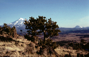
Mount Shasta and Black Butte from Shasta Valley
by Ken Goehring (used with permission)
This page prepared for Earth
Science 771 Remote Sensing
taught by James S. Aber at Emporia State University
©1997 Linda Freeman