

Medicine Lake Highland
Thematic Mapper Bands 2, 4, 7 (May 20, 1988)

 Medicine Lake Highland is located in northern California to the northeast of
Mount Shasta in Siskiyou County. The Highland is an eastern extension of the
Cascade Range. The Cascade Range is a chain of volcanoes extending from Meager
Mountain (north of Mount Garibaldi) in British Columbia to Mount Lassen in California.
This volcanic chain is a result of subduction of small microplates beneath the
North American Plate.
Medicine Lake Highland is located in northern California to the northeast of
Mount Shasta in Siskiyou County. The Highland is an eastern extension of the
Cascade Range. The Cascade Range is a chain of volcanoes extending from Meager
Mountain (north of Mount Garibaldi) in British Columbia to Mount Lassen in California.
This volcanic chain is a result of subduction of small microplates beneath the
North American Plate.
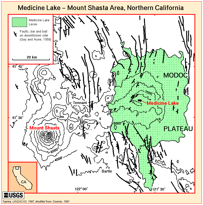
Medicine Lake Volcano is a young shield volcano which began forming about a million years ago. It is not as tall as the stratovolcanoes such as Mount Rainier and Mount Shasta; however, it is the largest volcano in the Cascades with an estimated volume of 600 km3 (Donnelly-Nolan, 1988). If you compare its "footprint" to Mount Shasta, you will see how much larger in area it is. This volcanic region lies atop an older (15 to 30 MYA) volcanic region, the Modoc Plateau.
The exposed rocks in the Cascades are mainly extrusive; that is, they cooled outside of Earth's surface (as opposed to intrusive rocks which cooled beneath the Earth's surface). Common surface rocks in this region include basalt, andesite, dacite, and rhyolite. Because these rocks cooled quickly they are fine-grained in texture. Basalts tend to be light to medium gray. Andesites are dark gray to black. The dacite I've seen is gray with flecks of darker colors in it or almost black with lighter flecks. Rhyolite is light-colored unless it is obsidian.
 In
addition to the varying composition, rocks have different expressions depending
on the circumstances surrounding the rock's formation. When a rock cools so
fast that no crystalline structure is developed then the rock is called an obsidian,
which is typically rhyolitic or dacitic in composition. If the rhyolite (or
dacite) is frothy when it cools then it becomes pumice. Rocks made from
volcanic ash and small volcanic fragments (such as pyroclastic flow deposits)
welded together are called tuff. Basalt and andesite sometimes have interesting
rock textures such as aa (blocky) and pahoehoe (ropy-looking)
as well as volcanic bombs in the region. Satellite imagery is affected by
the composition of the rock as well as its form.
In
addition to the varying composition, rocks have different expressions depending
on the circumstances surrounding the rock's formation. When a rock cools so
fast that no crystalline structure is developed then the rock is called an obsidian,
which is typically rhyolitic or dacitic in composition. If the rhyolite (or
dacite) is frothy when it cools then it becomes pumice. Rocks made from
volcanic ash and small volcanic fragments (such as pyroclastic flow deposits)
welded together are called tuff. Basalt and andesite sometimes have interesting
rock textures such as aa (blocky) and pahoehoe (ropy-looking)
as well as volcanic bombs in the region. Satellite imagery is affected by
the composition of the rock as well as its form.
The goal of this project is to determine which composite images using Landsat multispectral scanner (MSS) and Landsat thematic mapper (TM) data will best portray geologic formations in this volcanic region of the western United States. In particular, MSS data taken on June 8, 1992 and TM data from May 20, 1988 will be utilized. The MSS data was taken during a drought so it will be utilized more than the TM data, which has snowcover on the Highland. I will focus on a MSS subscene of the Medicine Lake Highland from approximately 41°45'N, 122°W to 41°N, 121°W (see map which covers approximate area). When I utilize the TM data it will be for smaller subscenes at lower elevations.
The first step in the process is to create the basic 24 composite images from the four bands of MSS data. To see the results of this section, please visit MSS Composite Images. A few digital images are included to give you a better impression of the landforms.
Band ratioing combines two bands of data which can then be used in creating other composite images. Band ratioing removes shadows, emphasizes color, and creates a single image with information from two images, thus making it possible to see more information at once. Using the four MSS bands it is possible to create 12 different ratio combinations. You can examine the results of using band ratios at MSS Composite Images Using Band Ratios.
The multispectral scanner, which was first tested in 1972 on ERTS-1 (Earth Resources Technology Satellite), was such a success that it became the the main sensor on later Landsat satellites. The group which developed the MSS then created a new scanner called the thematic mapper which was capable of recording seven bands of data. Seven bands of data provide numerous possible combinations when creating composite images.
Following are stretched images for each band (linear stretch with 5% saturation) of a May 1988 subscene showing Giant Crater Lava Flow. The online version of this presentation will only access the smaller versions of the images while the CD will also contain the larger images. The larger views are very clear with easy-to-see roads, numerous cinder cones, and other interesting features. For example, you might want to take a peak at Timbered Crater.
| ~40K Images | ~900K Images |
|
|
|
I will further manipulate the 1988 TM data in hopes of distinguishing between the 6 groups of lava discussed under A Closer Look at the Giant Crater Lava Flow. The Callahan Flow is another compositionally zoned flow which will also be examined using TM data in the section entitled A Closer Look at the Callahan Lava Flow.
A bonus image of the Digital Elevation Model of the Alturas Sheet-West and Medicine Lake are available. If you are interested in the sources I used, you can view the Bibliography.
This page prepared Fall 1998 for Earth
Science 739 Research Problems
taught by James S. Aber at Emporia State
University
©1998 Linda Freeman