
![]()
The USGS Provisional 1986 topo map of Mount Shasta recognizes seven glaciers although Rhodes (1987) suggests there are ten extant glaciers. The seven glaciers recognized by the USGS are Whitney Glacier, Bolam Glacier, Hotlum Glacier, Wintun Glacier, Watkins Glacier, Konwakiton Glacier, and Mud Creek Glacier. The other glaciers are Upper Wintun Glacier, Chicago Glacier, and Olberman Glacier (Rhodes, 1987; Biles, 1989).
Glaciers on Mount Shasta were not described in the scientific literature until Clarence King published his observations of an 1870 expedition on Mount Shasta in the American Journal of Science in 1871. The first glacier King and his companions saw was Whitney Glacier, named after Josiah Dwight Whitney. King stated, "Its entire length in view was not less than 3 miles, its width opposite our station [on the rim of Shastina] about 4,000 feet..." (King in Russell, 1885). The next day they climbed the main peak and saw three more glaciers, "the largest about 4 1/2 miles in length and 2 or 3 miles wide." King pointed out that there were also relics of glaciers on the mountain.
J. D. Whitney and William Brewer of the Whitney Survey explored the mountain in 1862, prior to King's expedition (Russell, 1885; Farquhar, 1923; Hill, 1975; Biles, 1989). Not only did they not see any glaciers, Brewer stated in an 1862 letter to George Brush, "In this climate, although immense quantities of snow fall in winter, no rain falls during the long cloudless days of summer, so there are no glaciers." The letter describes how difficult the climb was; Whitney had "his fingers frostbitten" and much of the day was cloudy.
Although not published in the scientific literature, glaciers on Mount Shasta were known about as early as 1866, prior to the scientific explorations. Following is an excerpt from an 1866 article in the Yreka Journal:
Crater and Summit of Mount Shasta -- A New Route
YREKA, August 24
...The wonder
is that no one before ourselves has ever attempted to make the ascent
by this route, which winds on a comparatively easy grade around
the mountain to its summit. It is very evident why the new way is so agreeably
bare of drifted debris. Vast quantities of snow and ice have at different
periods gathered and become packed between the two summits, until forming
an immense glacier, which would in time by its great weight, break away
and go sliding and plowing down the mountain, carrying with it everything
movable. By this means the very ribs of the mountain have been planed
and polished, and in places sharply grooved, the grooves invariably running
downward and parallel with each other.
We were not far from the base of
the crater's wall when the stars began to pale in the dazzling light of
heaven, and soon rosy sunshine flooded the world of our vision except
where the shadows of great mountains stretched away to the west; that
of Shasta like a dense, black, pall lying prone across the land, its apex
well defined against the western sky.
When looking from below we supposed
if we could reach the crater at all, it must be by the ravine to the divide,
but arriving at the base of the wall, and finding the rocks lying against
it quite large and firm, we resolved to scale straight over the intervening
space of probably twenty-five hundred feet to the top. This we did, and
emerging upon the grand ramparts, which as jaws encircled the terrible
mouth of Shasta, whose bellowings therefrom once shook the continent,
we uncovered our heads in reverence and in awe of the mighty power which,
though not active, manifestly exists in repose.
"We were the first that ever burst
Upon that silent scene,"
And greeting
old Shasta with a loud cheer, "the long silent cliffs were glad to
peal it back again." The crater upon the top is nearly circular in
form, and about one mile in diameter, its walls in many places being about
two hundred feet in height and nearly perpendicular, the inside bearing
unmistakable evidence of the great heat once coming from below, in plating
the exposed parts with black obsidian--glass. In the bottom there are
three little lakes, or ponds, of ice having a deep green tinge, evidence
of great depth. These, after the manner of scientific explorers, we modestly
named Lake Ensign, Lake Sisson, and --Chauncy's pond...
The large ravine which lies between
the main peak and the crater, on the northwest, holds at its head a grand
and extensive glacier of snow and ice. The accumulated snows of a hundred
winters from either side of the mountain are here packed, and the huge
mass is now breaking, has moved, in fact, and may soon come crushing down
the mountain to Shasta Valley. Where it is breaking a great number of
immense fissures are visible, some of them hundreds of yards in length,
and ten or twenty feet wide. Their depth we had no means of ascertaining.
Looking down the mountain in this direction, Mr. Sisson called our attention
to what he termed a grand natural road, which is a peculiarly well-defined
smooth place of several hundred yards in width, and of uniform appearance
throughout its length, at least eight miles. This is undoubtedly the track
of descending glaciers that have at intervals of perhaps fifty years (I
judge of the time by the appearance of the trees now growing upon this
road, as compared with those on the outside, and assuming that the present
glacier is about to break away--but this may be little better than conjecture)
broken away from the location of the present one.
Having spent several hours viewing
the wonders of the crater and glacier, we started up the main peak...
In 1882 Gilbert Thompson conducted a topographical survey. They observed five major "ice streams" and pointed out that a "careful examination of some of the ice-bodies on the western flank of Mount Shasta would perhaps lead to their being classed as glaciers of secondary magnitude..." (Thompson in Russell, 1885). Thompson made an interesting statement that photos from 1870 showed there was more snow than when he made the climb in 1882.
Joseph Silas Diller worked in place of C. E. Dutton for a 1883-84 USGS survey of Mount Shasta. He made several later publications relating to Mount Shasta, among them Mount Shasta, A Typical Volcano (1895). In this monograph, he discusses five glaciers of Mount Shasta, Whitney, Bulam [sic], Hotlum, Wintun, and McCloud [Konwakiton].
Following is a set of tables of the five major glaciers. The information is based on articles which contained data about the length, width, or volume of a glacier.
Descriptions of the Five Major Glaciers of Mount Shasta, 1871 - 1986
| Whitney Glacier | ||||||||
| Person | Year | Length | Width | Area | Volume | Maximum Thickness |
Special Features | |
| King | 1871 | 3 miles | 4,000' | - |
- |
- |
terminal moraine indicates previously larger size | |
| Thompson | 1882 | 3,800 yd | - | 1.9 M yd2 |
- |
- |
most typical ice stream, terminus at 9,500' | |
| USGS | 1884 | 9240' | 1320' | - | - | - |
- |
|
| Diller | 1895 | 2 1/5 mi | 1,000'- 2,000' |
- | - |
- |
most like in the Alps, jagged upper part, 100' deep crevasses | |
| Drieger & Kennard |
1986 | - |
- |
14 M ft2 | 0.9 B ft3 | 126' | most ice between 10,000-11,000' and 12,000-13,000' | |
| Hotlum Glacier | ||||||||
| Person | Year | Length | Width | Area | Volume | Maximum Thickness |
Special Features | |
| King | 1871 | 1.5 mi in canyon section |
broad |
- |
- |
- |
E slope, milky stream, cascading crevasses, rounded section | |
| Thompson | 1882 | 3,200 yd |
- |
1.8 M yd2 |
- |
- |
arc of terminal moraines, foot of glacier at 10,500' | |
| USGS | 1884 | 10,560' | 7920' |
- |
- |
- |
- |
|
| Diller | 1895 | 1.62 mi | 1.23 mi |
- |
- |
few hundred | medial moraine, deeply crevassed to 100' deep | |
| Drieger & Kennard |
1986 |
- |
- |
19.4 M ft2 | 1.3 B ft3 |
- |
- |
|
| Bolam Glacier | ||||||||
| Person | Year | Length | Width | Area | Volume | Maximum Thickness |
Special Features | |
| King | 1871 | 4-5 mi | 3-4 mi |
- |
- |
1,800' - 2,500' |
N slope, immense crevasses, concentric fissures | |
| Thompson | 1882 |
- |
- |
- |
- |
- |
- |
|
| USGS | 1884 | 7920' | 2640' |
- |
- |
- |
- |
|
| Diller | 1895 |
- |
- |
- |
- |
- |
broader, less definite valley | |
| Drieger & Kennard |
1986 |
- |
- |
11.4 M ft2 | 0.8 B ft3 |
- |
- |
|
| Wintun Glacier | ||||||||
| Person | Year | Length | Width | Area | Volume | Maximum Thickness |
Special Features | |
| King | 1871 |
- |
- |
- |
- |
- |
NE slope | |
| Thompson | 1882 | 3,400 yd | 1,000 yd | 2M yd2 |
- |
- |
curving crevasses, terminus 8,000', stream loaded with mud and silt | |
| USGS | 1884 | 10,560' | 2,640' |
- |
- |
- |
- |
|
| Diller | 1895 | 2+ mi |
- |
- |
- |
- |
abrupt front of ice, no terminal moraine | |
| Drieger & Kennard |
1986 |
- |
- |
13.2 M ft2 | 0.9 B ft3 |
- |
- |
|
| Konwakiton Glacier | ||||||||
| Person | Year | Length | Width | Area | Volume | Maximum Thickness |
Special Features | |
| King | 1871 |
- |
- |
- |
- |
- |
- |
|
| Thompson | 1882 |
- |
- |
320,000 yd2 |
- |
- |
foot at 12,000' | |
| USGS | 1884 | 5,280' | 2,640' |
- |
- |
- |
- |
|
| Diller | 1895 |
- |
- |
- |
- |
- |
smallest glacier, referred to as McCloud Glacier | |
| Drieger & Kennard |
1986 |
- |
- |
3.2 M ft2 | 0.2 B ft3 |
- |
- |
|
![]()
![]()
![]()
![]()
![]()
Whitney Glacier
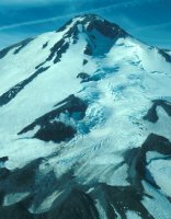
Whitney Glacier, named after the geologist Josiah Dwight Whitney, is the longest glacier in California (Rhodes, 1987; Biles, 1989) and the one which most resembles glaciers in the Alps (Thompson, 1882; Diller, 1895), being the only true valley glacier on Mount Shasta. Whitney Glacier flows from just below the peak of Mount Shasta in a northwesterly direction through the valley between Mount Shasta and Shastina. Whitney Glacier has the thickest ice measured on a Mount Shasta glacier at 126 feet (Driedger and Kennard, 1986).
P.J. Denand gives a report of a July 1928 (Southern Pacific) Expedition. He describes a "bed of a former glacier" but I cannot pinpoint the area based on his description. When the party finally reaches Whitney Glacier, their destination, Denand states, "All at once the moraine, glacial field, serracs, and the glacier itself loomed in front of us after crossing a last snowfield and turning a sharp bend. I have no words to describe this wonderful sight."
Carter (1984) described Whitney Glacier based on a climb in 1960 and 1983. His descriptions and photos make the glacier seem real (as I have not yet seen them in real life). Looking at an aerial photo of the north side of Mount Shasta, one can see there are two major sources for this glacier. Just to the west of Shasta's peak is the Whitney Glacier bergschrund. The ice flows down from here, crossing an arête and joining with a secondary glacier situated on the north side of Shastina Col. Once the two sections join together, the glacier cascades down the mountain in an icefall. At 10,000 feet the hikers reached their old campsite and there was a moraine gully with water flowing between the moraine and the mountainside which in 1960 was filled with ice and snow. Likewise, in 1960 they saw boulders perched on ice pedestals which were melted by 1983. Between the campsite and the icefall the climbers entered the serac zone composed of ice towers leaning this way and that. After an exhausting climb through the gendarmes, they found the way blocked by a crevasse and had to find another route. When they finally reached the top of the glacier, they found the bergshrund below Shastina Col a "gigantic crevasse" yawning below the headwall.
Meltwater flows from Whitney Glacier into Whitney Creek. Occasional debris flows cross Highway 97 and are deposited in a debris fan 20 km2 in size which reaches all the way to Lake Shastina (Osterkamp, Hupp, and Blodgett, 1986). The Mount Shasta Vista subdivision is located on this debris flow. A 1985 article from the Siskiyou Daily News shows the outcome of building in a flood plain:
Melting Glaciers Blamed For Runoff
Flooding Hits Subdivision
MOUNT SHASTA VISTA, July 9
Glaciers melting
at a fast pace due to recent high temperatures are blamed for Whitney
Creek flooding the Mount Shasta Vista subdivision Saturday night.
One home is threatened by the water,
which Saturday night cut a new channel for itself right through the subdivision.
At least three other homes may be in danger. Buckhorn Road, one of the
main roads in the subdivision, now has a three-foot deep channel of water
running the width of the road bed.
The water flow has not stopped and
according to Dick Ober of Klamath National Forest, will not stop until
Whitney Glacier which feeds the creek on Mt. Shasta ceases to melt. "Only
cold weather can accomplish that," Ober stated.
The flood caught subdivision residents
off guard despite flooding problems in the past. Mount Shasta Vista is
located on the flood plain of Whitney Creek. When snow melts on the mountain,
the water runs down into the plain, flooding it.
"We didn't think we'd have problems
this year because there's no snow on the mountain," stated Bill Lockwook,
subdivision president.
However, Ober said the runoff this
year is especially heavy as a result of continuous hot weather. "In
some places debris from the runoff is in trees at points 15 feet above
the ground," he said. "There must have been a huge amount of
water coming down."
Ober said the flooding was nature
doing its thing. The runoff is full of glacial deposits. "Sometimes
it comes down the mountain looking more like Jello than water because
of the deposits," he said.
The sediment settled once it reaches
the plain where the subdivision is located. Two old channels filled with
the muck and forced the creek to find a new channel, thus flooding the
subdivision Saturday.
While Ober said KNF wants to leave
nature alone, subdivision residents understandably want the water out
of their homes. Sherrie Ritchie, whose home is threatened by the flood,
tried to keep water off her property Sunday night by shovelling dirt in
its path.
"I had to give up because the
water knocked the dirt out faster than I could shovel it," she said...
![]()
![]()
![]()
![]()
![]()
Bolam Glacier
Bolam Glacier is located on the north slope of Mount Shasta. The meltwater drains into Bolam Creek, which joins with Whitney Creek and Graham Creek to form the Whitney-Bolam debris fan (Osterkamp, Hupp, and Blodgett, 1986).
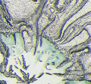
Bolam and Hotlum Glaciers
Segment of Plate XLIV of the 1883 Fifth Annual
Report

Bolam and Whitney Glaciers on the north side of Mount Shasta
Air photo taken by Linda Freeman on October 17, 1998
![]()
![]()
![]()
![]()
![]()
Hotlum Glacier
 Hotlum
Glacier is the largest glacier on Mount Shasta in area and volume, at 19.4
million square feet and 1.3 billion cubic feet respectively (Driedger and
Kennard, 1986). Hotlum Glacier is the only glacier in California with a
medial moraine (Diller, 1895; Rhodes, 1987). Diller (1895) further defines
it as, "...deeply crevassed, exposing the green ice... to depths of
100 feet." The terminal moraine of this glacier is a mile wide (Diller,
1895).
Hotlum
Glacier is the largest glacier on Mount Shasta in area and volume, at 19.4
million square feet and 1.3 billion cubic feet respectively (Driedger and
Kennard, 1986). Hotlum Glacier is the only glacier in California with a
medial moraine (Diller, 1895; Rhodes, 1987). Diller (1895) further defines
it as, "...deeply crevassed, exposing the green ice... to depths of
100 feet." The terminal moraine of this glacier is a mile wide (Diller,
1895).
While Hotlum Glacier is not famous for its mud flows, a July 12, 1928 article in the Mount Shasta Herald questioned whether Hotlum Glacier might not produce an avalanche that year. Stuhl, on returning from one of his expeditions, stated that the "old military road, over which General Canby traveled, is now impassable on account of the flow from Inconstance Creek." This creek flows from Hotlum Glacier and was "out of its banks;" while it had overflowed in past years, it never had this early according to local knowledge. The article further states that Ash Creek has muddy water each year but leaves no deposits and Mud Creek has always "been the creek to leave its bank and cause so much trouble."
![]()
![]()
![]()
![]()
![]()
Wintun Glacier

Wintun Glacier
Air photo taken by Linda Freeman on October 17, 1998
Wintun Glacier is on the southeast side of Mount Shasta. Rhodes (1987) believes this glacier should be divided into 2 glaciers, Wintun Glacier and Upper Wintun Glacier, but this is not recognized by the USGS. The meltwater of Wintun Glacier flows into Ash Creek. Unlike most of the other streams on Mount Shasta, Ash Creek flows most of the year (Osterkamp, Hupp, and Blodgett, 1986). Wintun Glacier does not have a terminal moraine as mud flows from Ash Creek have formed, along with mud flows from Mud Creek, the 300 km2 Mud-Ash debris fan north of the McCloud River (Diller, 1895; Osterkamp, Hupp, and Blodgett, 1986).
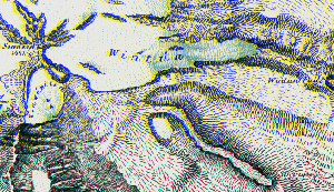
Wintun and Konwakiton Glaciers
Segment of Plate XLIV of the 1883 Fifth Annual
Report
![]()
![]()
![]()
![]()
![]()
Watkins Glacier
Watkins Glacier, also known as Clear Creek Glacier as it upslope from the springs which feed Clear Creek (a tributary of Mud Creek), is one of the glaciers of Mount Shasta recently recognized by the USGS. It formed during the Little Ice Ages and is located on the southeast side of the mountain (Rhodes, 1987). There is a "well preserved Mathes moraine" on Watkins Glacier (Rhodes, 1986).

Watkins Glacier (the smaller, lower glacier)
Air photo taken by Linda Freeman on October 17, 1998
Watkins Glacier is named after R. Harry Watkins, Jr., a late Siskiyou County resident who tried to have this glacier recognized for much of his lifetime. It is speculated in an issue of the Mount Shasta Herald (Heston, 1978) that even though this cirque glacier was depicted on a 1883 USGS sketch, it was not recognized as a true glacier due to the name of the creek below its base. Streams flowing from glaciers have rock flour in them, resulting in a milky appearance; the name Clear Creek suggests otherwise. In the same article, Watkins is quoted as saying, "I'm the champion of this little tiny glacier. That's what I'm interested in -- to get people to recognize it." The letter granting him this long sought-after recognition follows:
United States
Department of the Interior
Geological Survey
Water Resources Division
1305 Tacoma Avenue South
Tacoma, Washington 98402
January 29, 1976
Mr. R. H. Watkins
P.O. Box 896
Mount Shasta, California 96067
Dear Mr. Watkins:
Your January 23 letter and enclosures regarding "Clear Creek" or "Lost" Glacier on Mt. Shasta is of much interest. This is a true glacier by I.H.D. definition, as are all of the perennial snowfields on the mountain which exceed 0.1 km2 in area.
As for a name for this active, and in 1959 possible advancing glacier, my thought is that Mr. Rhodes' suggestion that this glacier be named for you is a good one in view of your long outstanding interest in Mt. Shasta. I have suggested to Mr. Rhodes that your name be reserved for this feature for possible future consideration.
Please let us know whether you wish the photos you sent returned or whether they may be retained for the Data Center files.
Again our thanks for showing your photos and data. Your letter as well as other material you donate will go into the permanent files.
Sincerely,
Austin Post
Acting Director
World Data Center-A, Glaciology
![]()
![]()
![]()
![]()
![]()
Konwakiton Glacier
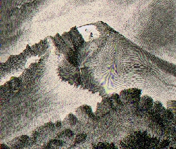
Konwakiton Glacier and Mud Creek
Segment of Plate XLV of the 1883 Fifth Annual Report
Konwakiton Glacier, which means "muddy" in the Wintu language, has also been called McCloud Glacier (Diller, 1895). This glacier used to be much larger (Diller, 1895; Biles, 1989) and rocks with striations can be found here. The meltwater from Konwakiton flows over a waterfall into Mud Creek, which is located in a V-shaped, ash-layered canyon. Konwakiton Glacier is the source for many of the jökulhlaups, or glacial outburst floods, of this century.

Air photo of Konwakiton Glacier
USGS
![]()
![]()
![]()
![]()
![]()
Mud Creek Glacier
Mud Creek Glacier is another of the glaciers recently recognized on the USGS 1986 Provisional topographical map of Mount Shasta. It is located directly south of Konwakiton Glacier, but is to the west of Mud Creek, above a 11,267 foot peak just to the east of Sargents Ridge. While not labeled as a glacier on a USGS map until 1986, a 1935 newspaper describes an...
Unnamed Glacier on Mt. Shasta
MOUNT SHASTA, September 26
While on one
of his almost weekly hikes over Shasta, John Hughes of the local branch
of the California experimental station, made a definite decision that
there is a sixth glacier on Shasta, unmapped and unnamed, although known
to exist by many who are familiar with the upper sections of the mountain.
The glacier is sometimes referred
to as the Mud Creek glacier, but Konwakiton glacier is commonly known
as Mud Creek glacier and as the unnamed and unmapped glacier is removed
from Konwakiton it should be identified on the maps, but no maps show
it.
The unnamed glacier lies over the
divide from the head of Panther creek, about 1000 feet below Konwakiton,
with the runoff going into the Mud Creek gorge over a waterfall of more
than 100 feet. The water runs across the glacier in a stream about four
feet in width. This glacier has no crevasses, which likely indicates that
it rests on a smooth surface. A 50-foot ledge of ice faces the gorge.
The waterfall on this glacier can be seen when coming down the mountain.
Hughes will report his information
to the department of interior for study. Another thing that studies of
the mountain have brought out is that Thumb Rock on the new maps is not
Thumb Rock, as known to the people familiar with Shasta. The rock designated
as Thumb Rock on the maps is on the same ridge, but a thousand or more
feet below the real Thumb Rock. This is to be reported also. It appears
that closer studies of the mountain during the past few weeks have brought
to light many irregularities in names and maps. The confusing names of
Inconstance creek was another instance. This was discussed at length in
the Herald a few weeks ago.
There is much action in the Mud Creek
gorge, with rocks falling and rolling continually. It would be almost
impossible to go into the gorge any distance at the higher elevations
on account of the danger.
![]()
![]()
![]()
![]()
![]()

Air photo of Mud Creek Glacier
USGS
The disagreement as to the number of glaciers which exist on Mount Shasta can be readily understood if one can envision the entire scenario. Scientific expeditions have been conducted on Mount Shasta since 1870 and have continued to the present. The climate has changed during this time, so that in some years the snowfall would cover any small glaciers that may have been in existence at that time. During the times of drought, the smaller glaciers may have receded to the extent that they were no longer recognizable as glaciers, yet in wetter years their regrowth would enable them to again be considered glaciers. When is a receding glacier no longer considered a glacier? Another major point is that maps are typically not revised and reprinted each year, so that it may appear that certain glaciers aren't recognized, when, in fact, they have been.
Although Konwakiton glacier is one of the smaller glaciers on Mount Shasta, it is the one that has the largest effect on the local population. Mud flows produced from Konwakiton Glacier will be discussed in the next section.
![]()
![]() Location
Location
![]() Brief Geology
Brief Geology
![]() Pleistocene
Pleistocene
![]() Holocene
Holocene
![]() Glaciers
Glaciers
![]() Jökulhlaups
Jökulhlaups
![]() Bibliography
Bibliography
![]() Glossary
Glossary
![]()
![]()
This page prepared for Earth Science 767 Quaternary
Geology
taught by James S. Aber at Emporia State University
©1997 Linda Freeman
![]()