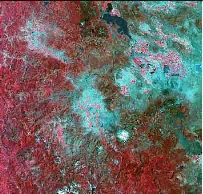
Standard False-Color Composite (4,2,1) Preview Image
| Meta Data Details | |
|---|---|
| Entity Id : | LM4045031009216090 |
| Acquisition Date : | 1992/06/08 |
| Northwest Latitude : | N42 39 37 |
| Northwest Longitude : | W123 11 40 |
| Northeast Latitude : | N42 20 17 |
| Northeast Longitude : | W120 59 00 |
| Southeast Latitude : | N40 51 58 |
| Southeast Longitude : | W121 29 50 |
| Southwest Latitude : | N41 10 51 |
| Southwest Longitude : | W123 39 37 |
| Browse Availability : | YES |
| Date of Update : | 1996/11/20 |
| Center Nadir Latitude : | N41 46 00 |
| Center Nadir Longitude : | W122 20 00 |
| Cloud Cover : | 0 |
| Path : | 45 |
| Row : | 31 |
| WRS Type : | Landsat 4,5 |
| Quality : | Very Good |
| Recording Technique : | MSS Descending (Day). |
| Receiving Station : | EROS Data Center, SD, USA |
| Microframe : | 7904390979 |
| Condition : | Scene not affected by a condition problem. |
| B/W Film Availability : | YES |
| B/W Film Quality : | 8888# |
| CCT Availability : | An E type CCT is available |
| Area Indicator : | S |
This page prepared for Earth Science 775 Advanced
Image Processing
taught by James S. Aber at Emporia State
University
©1998 Linda Freeman