


by Linda Freeman
This web presentation is my semester project for Advanced Image Processing. In addition to it being downright fun manipulating satellite data, it is an educational experience. I would like to share portions of what I have learned with:
Join me on any or all of my adventures!
 A
Virtual Tour of Mount Shasta
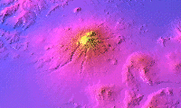
A
Virtual Tour of Mount ShastaCheck out the Mount Shasta region through maps, photos, DEMs, and satellite imagery.
 Processing
Multispectral Scanner Data with Idrisi
Processing
Multispectral Scanner Data with IdrisiLearn where to find data online and how to manipulate it using Idrisi software.
 Examining
the 1987-1992 Drought in Siskiyou County
Examining
the 1987-1992 Drought in Siskiyou CountyA brief examination of the drought in Siskiyou County, California using satellite imagery.
I would like to thank the College
of the Siskiyous for providing the funds for the MSS data
and Dr. Aber and Emporia State University for offering online courses.
This page prepared for Earth Science 775 Advanced
Image Processing
taught by James S. Aber at Emporia State
University
©1998 Linda Freeman