


Introduction ~ Preparing the Data ~ Describe ~ Stretched Images ~ Composite Images ~ Ratio Images ~ NDVI ~ Boolean Images ~ Filtering ~ Composite Ratio Images ~ Unsupervised Classification ~ Conclusion ~ References
The goal of this section is to describe how to process MultiSpectral Scanner (MSS) data using Idrisi software. I am assuming the reader of this page has had some experience in remote sensing or has the desire to learn more about it. I am currently taking my second class in remote sensing and this is basically an overview of what I have learned so far.
MSS data has been collected by Landsat (formerly known as Earth Resources Observation Satellites or EROS) since 1972. The main sensor for Landsat 1 was supposed to have been a return beam vidicom (RBV) camera but as it turned out the experimental MSS became the lead sensor for Landsat 1, Landsat 2, and Landsat 3. It was so successful that an improved version which had better resolution was developed. This new scanner, called the Thematic Mapper (TM), was the main sensor on Landsat 4 and Landsat 5 but MSS was also utilized on these missions. Landsat 6 was supposed to have carried the Enhanced Thematic Mapper (ETM), but it failed to obtain orbit. An even better model (ETM+) will be carried on Landsat 7 which is scheduled to launch in the fall of 1998.
There are certain characteristics of MSS data that should be discussed prior to beginning this project. There are four spectral bands gathered by the scanner. Band 1 records the wavelengths between 0.5-0.6 µm, which corresponds to what we see as green. This band is especially useful for studying water because it has good depth penetration and detects turbidity. Band 2 is equivalent to red in the visible spectrum and ranges from 0.6-0.7 µm. This band is especially good for vegetation studies as vegetation absorbs energy in this portion of the spectrum for photosynthesis. Band 3 records 0.7-0.8 µm, which is outside the visible spectrum in the infrared (IR) portion of the electromagnetic spectrum. Vegetation reflects infrared radiation so this band is also useful for vegetation studies. Band 4 is also infrared, ranging from 0.8-1.1 µm. Band 4 is usually preferable over Band 3 as it has better contrast.

MSS scenes can be searched for and purchased through WebGlis at http://edcwww.cr.usgs.gov/webglis/. You can even view many of the scenes prior to purchase, which will enable you to choose the best image possible. When purchasing data keep in mind your goals, the quality of the image, cloud cover, and date it was taken.
I selected a non-drought scene and a drought scene of the Mount Shasta region taken on June 13, 1985 and June 8, 1992, respectively. I will later use images created by following the procedures outlined in this section to try and determine if the impact of the drought in northern California can be detected with satellite imagery.
In the following sections I will:
![]()
If you order your data on a CD then you will need to get it into the proper format before Idrisi can read it. Since I had such a hard time with this part, I will describe the steps that need to be taken.
First, look at what files are on your disk with the file manager (Netscape Explorer in Windows95). There should be eight files. The *.sum file is an order file summary and it isn't needed in this process. The *.hi file is a processing history for the work order and it isn't necessary either. There are some interesting items in the *.wo file but you won't be using those.
That leaves five files which are essential. The *.hd and the *.i* files. The *.i* files need to be renamed, but that is all. The number after the .i in the extension is the band number, so you should use that in your file name. The extension needs to be changed to .img. So, for example, I changed my Lm404503.i1 to ms1992-1.img, Lm404503.i2 to ms1992-2.img, Lm404503.i3 to ms1992-3.img, and Lm404503.i4 to ms1992-4.img (where ms stands for Mount Shasta, 1992 is the year the scene was obtained, plus the band number followed by the .img extension).
The *.hd file contains the information you will need to make your *.doc file which will accompany each band. Check out what the *.doc file should look like (the blue part below). Note that this is a text file saved with a .doc extension which is somewhat confusing as this is NOT a Word document, it is the extension Idrisi uses for the documentation file which provides needed information about each image file. You will need to make a *.doc file for each band, using the same naming scheme you used for the image files but with a .doc extension. The gray box on the right shows either what to put in or where to get the information. The only things that will be different between the files for each band are the band number on the title and value units and the min. value and max. value, which you will temporarily set at 0 and 255 respectively.
| file title : MOUNT SHASTA (08 JUNE 92) BAND 1 data type : byte file type : binary columns : 3446 rows : 3519 ref. system : plane ref. units : km unit dist. : 1 min. X : 0 max. X : 196.422 min. Y : 0 max. Y : 200.583 pos'n error : unknown resolution : 0.057 min. value : 5 max. value : 127 value units : mss 1 value error : unknown flag value : none flag def'n : none legend cats : 0 |
give title a NAME, DATE, and BAND NUMBER this is from the line PIXEL_FORMAT= leave file type as binary the columns # is from PIXELS_PER_LINE= the rows # is from LINES_PER_DATA_FILE= leave ref. system : plane leave ref. units : km leave unit dist. : 1 min. X = 0 to get max. X multiply columns # by resolution (below) min. Y = 0 to get max. Y multiply rows # by resolution (below) leave pos'n error : unknown resolution is found at PIXEL_SPACING= (change to km) for now make min. value : 0* for now make max. value : 255* make value units the band number after the mss leave value error : unknown leave flag value : none leave flag def'n : none leave legend cats : 0 |
*After you learn to use the histogram feature in the next section you can change these numbers.
It may be that the scene you ordered is too large for your situation (limited computer memory or delimited study area). You can resize your *.img files and their accompanying *.doc files in one fell swoop through the WINDOWS command. First of all view the entire image to find where you want to place your corners. Select Reformat - Window from the MenuBar then select Batch-window. Highlight the four image files (each band) that you will be resizing. Select the Replace initial characters with prefix (so you don't erase the original data) and choose a prefix that will replace the original prefix (for instance, when I wanted to take a closer look at Mount McLoughlin, I made the ms1992-1.img into mm1992-1.img by choosing mm as the prefix). Then enter the corners (upper column and row and lower column and row) and select OK. Your large images will be made into smaller ones in the wink of an eye.
![]()
The first thing you need to do with remote sensing data that you plan
to manipulate is learn more about it. The DESCRIBE feature of Idrisi does
just that. Select File - DESCRIBE from the MenuBar or click on the
Describe button ![]() .
You will already be familiar with this file (shown in the blue box above)
if you had to modify your files to use in Idrisi. If you obtained the data
in a format ready for Idrisi, then select the Image File you want to open
and you will find the necessary information.
.
You will already be familiar with this file (shown in the blue box above)
if you had to modify your files to use in Idrisi. If you obtained the data
in a format ready for Idrisi, then select the Image File you want to open
and you will find the necessary information.
After examining the data, click on the Image Histogram button to see a histogram of the data. Not only will this give you a visual representation of the data, but it also provides a statistical summary.
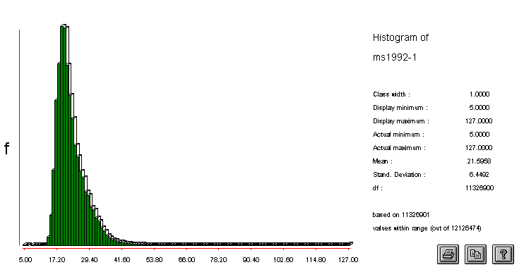
Histogram of Band 1 of the June 1992 Mount Shasta Scene
If you had to create *.doc files then this is when you can adjust the min. and max. values. Look at the numeric histogram data by choosing Display - Histo from the MenuBar, select the band you want to examine, set the minimum to 0 and maximum to 255, click on numeric under Output Type then push the OK button. Adjust the minimum and maximum values to reflect the data.
To determine the size of the file either multiply rows by columns then divide by 1024 (for byte size) or check your file manager (such as Windows Explorer in Windows 95).
![]()
The STRETCH function in Idrisi is used to increase contrast which
will make it easier to visually interpret the image. There are three types
of STRETCHing but we will use a linear STRETCH with saturation because
it preserves aspects of the original data. To STRETCH an image, either
click on the STRETCH button ![]() or
select Display - STRETCH from the MenuBar. Enter or choose (by double-clicking
in the white box) the Input Image and give the stretched image (Output
Image) a name. For the Stretch Type select Linear with Saturation. The
Percent to be Saturated will usually be between 2.5-5.0 (this will cut
off the tails of the histogram) and the other selections should be left
as is. Give your file a title, such as Band 4 Stretched, then click
on the OK button and you'll have a nice image which is saved in your working
directory. You can then save this image to the clipboard if desired by
selecting the Save Composition button on the Composer then choose Screen
Dump Map to Clipboard then click on OK. You can then crop the image from
the clipboard in a paint program and save it in the desired format.
or
select Display - STRETCH from the MenuBar. Enter or choose (by double-clicking
in the white box) the Input Image and give the stretched image (Output
Image) a name. For the Stretch Type select Linear with Saturation. The
Percent to be Saturated will usually be between 2.5-5.0 (this will cut
off the tails of the histogram) and the other selections should be left
as is. Give your file a title, such as Band 4 Stretched, then click
on the OK button and you'll have a nice image which is saved in your working
directory. You can then save this image to the clipboard if desired by
selecting the Save Composition button on the Composer then choose Screen
Dump Map to Clipboard then click on OK. You can then crop the image from
the clipboard in a paint program and save it in the desired format.
In the table below are sections of four regular images of each of the June 1992 bands, and four STRETCHed images. Notice the difference between them.
|
Band 1 |
Band 2 |
Band 3 |
Band 4 |
|
| Unstretched |  |
 |
 |
 |
|
Stretched |
 |
 |
 |
 |
The STRETCHed images are lighter. It is easier to see water, especially in Bands 3 and 4 (because water absorbs infrared radiation). From north to south, almost in the center of the image, is Iron Gate (near top of image), Lake Shastina (northwest of Mount Shasta), and Siskiyou Lake (at bottom edge). Shasta Valley is the large feature to the northwest of Mount Shasta and is especially prominant in Bands 1 and 2.
![]()
A composite image is created by combining three bands into one image. Each band has a color (red, green, blue) assigned to it before they are combined. Because MSS does not record the blue portion of the spectrum, we cannot create an image which corresponds to what our eyes would see and so the images that are created are called false-color composites.
Using different band/color combinations allows certain features of the environment to be emphasized. The most common false-color composite image uses Band 1 (blue) , Band 2 (green) , and Band 4 (red) and is called a standard false-color composite. Using this particular band/color combination, water shows up as blue to black, with clear, deep water darkest and shallow, silty water a lighter blue. Vigorous vegetation shows up as red and other vegetation as pink. Cities appear as bluish-gray and clouds and snow are white. This type of composite image is sometimes called a color infrared composite because it resembles infrared photography.
Creating composite images is probably the most useful feature in Idrisi or other remote sensing software packages. To create a composite image, select Display - COMPOSIT from the MenuBar. Enter the filename of the blue band, the green band, and the red band and give the new (Output) image a filename. Select Linear with Saturation Points to chop off the tails of the histogram, leaving the Percent to be Saturated at 2.5, enter a title (which should include the name of the scene, the date, and the bands used) and click on the OK button. Choose the Color Composite 256 palette to view the image. If you want to use this image in a paint program, choose the Save Composition button on the Composer then select Screen Dump Map to Clipboard then click on OK.
Following are a few composite images. Click on the small image to see a larger view.
 This
is the standard false-color composite using bands 1, 2, and 4. The bright
red indicates vegetation. This portion of the scene shows the Klamath Basin
National Wildlife Refuge. The section shown in the image to the left is
the Lower Klamath Refuge which is the first waterfowl refuge in the United
States (established 1908 by President Roosevelt). If you visit in the spring
you will have a good chance of seeing white pelicans. This
is the standard false-color composite using bands 1, 2, and 4. The bright
red indicates vegetation. This portion of the scene shows the Klamath Basin
National Wildlife Refuge. The section shown in the image to the left is
the Lower Klamath Refuge which is the first waterfowl refuge in the United
States (established 1908 by President Roosevelt). If you visit in the spring
you will have a good chance of seeing white pelicans. |
 This
is a naturalistic false-color composite as it is the
composite that most resembles how we would see the scene with our own eyes.
Since blue wavelengths are not recorded, however, it is impossible to achieve
a true natural color without extensive manipulation of the data. Certain
types of lava flows show up as dark purple with this combination of bands
1, 4, and 2. The purple blob to the left is the Burnt Lava Flow Virgin
Area in the Medicine Lake Highlands area. The topmost of the three green
"islands" is called High Hole Crater. Green signifies vegetation. This
is a naturalistic false-color composite as it is the
composite that most resembles how we would see the scene with our own eyes.
Since blue wavelengths are not recorded, however, it is impossible to achieve
a true natural color without extensive manipulation of the data. Certain
types of lava flows show up as dark purple with this combination of bands
1, 4, and 2. The purple blob to the left is the Burnt Lava Flow Virgin
Area in the Medicine Lake Highlands area. The topmost of the three green
"islands" is called High Hole Crater. Green signifies vegetation. |
 This
band combination of 2, 3, and 4 makes the algae in Upper Klamath Lake show
up very nicely. Upper Klamath Lake is Oregon's largest algae producer;
the algae is harvested by several companies. To the west of Upper Klamath
Lake (in the larger image) is Mount McLoughlin, the highest Cascade peak
between Mount Shasta and the Three Sisters. Water stands out with this
band combination. There are numerous lakes in the region which attract
people from Southern Oregon and Northern California. This
band combination of 2, 3, and 4 makes the algae in Upper Klamath Lake show
up very nicely. Upper Klamath Lake is Oregon's largest algae producer;
the algae is harvested by several companies. To the west of Upper Klamath
Lake (in the larger image) is Mount McLoughlin, the highest Cascade peak
between Mount Shasta and the Three Sisters. Water stands out with this
band combination. There are numerous lakes in the region which attract
people from Southern Oregon and Northern California. |
![]()
Band ratioing is accomplished by divided each pixel in one band by the corresponding pixel in another band until all pixels have been processed. Ratioing removes shadows and emphasizes colors, enabling better interpretation of the image. Using MSS data, there are 12 different band ratio combinations.
Prior to ratioing bands, haze correction needs to be performed. It should be kept in mind that there cannot be a zero in either the numerator or denominator and that the minimum value of each band should be 1. Therefore, you need to examine each band through the DESCRIBE feature in Idrisi by choosing File - Describe from the MenuBar. Look at the minimum value and determine the mathematical operation that needs to be performed to make that number a 1. Then go into SCALAR by selecting Analysis - Mathematical Operators - SCALAR from the MenuBar. Select the Input File, create a name for the new image (Output File), for the Operation select Add or Subtract then enter the number to be added or subtracted in the Scalar Value box. For record-keeping purposes, enter the operation you performed (such as +1 or -15) in the Value Units box. Finally, give the image a title, such as Band 1 Haze Corrected, then select OK. Do this for each band you will be using.
After each band is haze corrected, you can then create a ratio image.
Select Analysis - Mathematical Operators - OVERLAY from the MenuBar
or click on the OVERLAY button ![]() on
the ToolBar. Enter or select the haze corrected bands you will be using
for the First and Second image and create a filename for the Output image.
Choose the Overlay Option, which will be First/Second for the basic ratio
image. Then give your image a title, such as Band 1/Band 2, enter ratio
for the value units if desired, then click on the OK button. To view
the image you should STRETCH it but be sure to save the original file as
it will be used later.
on
the ToolBar. Enter or select the haze corrected bands you will be using
for the First and Second image and create a filename for the Output image.
Choose the Overlay Option, which will be First/Second for the basic ratio
image. Then give your image a title, such as Band 1/Band 2, enter ratio
for the value units if desired, then click on the OK button. To view
the image you should STRETCH it but be sure to save the original file as
it will be used later.
We are basically assuming that pixels that have the same ratio are the same thing, although this is not necessarily true. On the whole, the image will be enhanced because there are more pixels which depict the same thing but do not appear as if they do until the bands have been RATIOed than there are pixels which will look the same after RATIOing but which are really not the same.
Different ratios have different uses. For example, Band 4/2 is good for estimating the health of vegetation because the near infrared values (Band 4) increase and the red values (Band 2) decrease in healthy vegetation, resulting in a high ratio value for healthy vegetation. In this Band 4/2 ratio image, the green areas are vegetated.
In order to use these ratio images later in making composite images, they need to be changed to byte-binary. You can accomplish this by using SCALAR to multiply by a number that will increase the maximum value to somewhere between 240-255. Then CONVERT this file to byte-binary format by choosing Reformat - CONVERT from the MenuBar. Enter the Input File then give a name to the Output file and choose Byte for Data Type and Binary for File Type by Rounding then select OK. In addition to making this file more usable, it also makes it smaller.
![]()
The Normalized Difference Vegetation Index (NDVI) is a special ratio used to detect vegetation. Because plants absorb red for photosynthetic processes and reflect infrared radiation there will be a wide range between red and infrared in healthy vegetation. To offset the effects of shadows, the NDVI divides the difference between the infrared and red bands by the sum of the infrared and red bands, thus NDVI = (infrared - red)/(infrared + red).
The process used to create an NDVI ratio is the same as that for a normal ratio, except instead of choosing First/Second for the Overlay Option, you will select (First - Second) / (First + Second) and enter NDVI for Value Units. Make certain that the First image is either Band 3 or 4 (infrared) and the Second image is Band 2 (red).
NDVI images are useful to compare scenes between seasons in the same year or between like seasons in different years. This may enable the cycle of growth in a region to be determined or the effects of drought to be examined. It can also show deforestation or desertification if you have scenes from different years.
 The
image to the right is an NDVI of the June 1992 scene. The brown is snow
or water, the tan and yellow areas are sparsely vegetated areas, and green
is vegetation. The darker green areas in the northwest portion of the image
are valleys among the hills and are relatively wet grasslands. The darker
green south of Mount Shasta is oak/pine woodlands and is thicker here because
the rainfall is higher.
The
image to the right is an NDVI of the June 1992 scene. The brown is snow
or water, the tan and yellow areas are sparsely vegetated areas, and green
is vegetation. The darker green areas in the northwest portion of the image
are valleys among the hills and are relatively wet grasslands. The darker
green south of Mount Shasta is oak/pine woodlands and is thicker here because
the rainfall is higher.
If you want to use your NDVI image in a composite hybrid-ratio image (discussed below) then you first need to make some adjustments. Since we want the range of values to be close to 255 and this image ranges between -1 to 1, perform the following calculation (NDVI + 1) x 125 by using SCALAR (described above). First add 1 then perform the operation again, this time multiplying by 125. Then change your image into byte-binary format using CONVERT, also described above.
![]()
This process is used to compare water surface area between two scenes. I will be comparing a subset of the 1992 dought scene with the 1985 non-drought scene. The subset I have selected covers the Lower Klamath Refuge and the Tule Lake Refuge of the Klamath Basin because there are many lakes in this region.
First we are going to make a 4/2 ratio which will emphasize land/water contrasts. Prior to making the ratios, be sure to haze correct Band 2 and Band 4 as described in the Ratio Images section above.
After you have Band 4/2 prepared, then you will create a boolean image
using RECLASS. Select Analysis - Database Query - RECLASS from the MenuBar
or click on the RECLASS button ![]() .
The type of file you are using is an image file. Select User-Defined classification
type. The input file is the 4/2 ratio you just made. Name the output file.
Assign a new value of 1 to all values from 0 to just less than 1.01. Assign
a new value of 0 to all values from 1.01 to just less than 999. Select
OK and a boolean image with 2 colors will be created. If you use the Qualitative
16 palette then land will be black and water blue.
.
The type of file you are using is an image file. Select User-Defined classification
type. The input file is the 4/2 ratio you just made. Name the output file.
Assign a new value of 1 to all values from 0 to just less than 1.01. Assign
a new value of 0 to all values from 1.01 to just less than 999. Select
OK and a boolean image with 2 colors will be created. If you use the Qualitative
16 palette then land will be black and water blue.
Now, to find out how much land and water there is, use Analysis - Database Query - Area. Enter the boolean image you just made for the input image. Give the output file a name. Select Tabular Output Format then choose which type of unit you want to calculate your area as then click on OK. Category 0 will show how much land there is and Category 1 shows how much water there is.
My analysis of the Klamath Basin showed that the 1992 subscene had 21,100.84 acres of land and 1,044.77 acres of water. The 1985 subscene of the same region had 20,444.55 acres of land and 1,701.07 acres of water.
Filtering is another mechanism used to enhance an image. In addition, filtered images can be used in hybrid composite images (which are described in the next section). In this section you will learn to use a high-pass filter, a low-pass (mean) filter, and a Sobel Edge Detector.
A high-pass filter emphasizes the high-frequency portion of the image, which means that neighboring pixels are quite different from each other, such as on a steep slope. High-pass filters emphasize details. To create a high-pass image
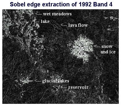 The
Sobel Edge Detector is a nifty filter because it detects the boundary
between features. The procedure is the same as described for the high-pass
filter, except that Sobel Edge is selected as th filter type. The Sobel
Edge Detector is useful in finding water-land boundaries or other
types of changes, such as in vegetation types. You might want to try this
type of filtered image in a hybrid composite image as described in the
next section. If so, be sure to CONVERT the image
into byte-binary, as described above.
The
Sobel Edge Detector is a nifty filter because it detects the boundary
between features. The procedure is the same as described for the high-pass
filter, except that Sobel Edge is selected as th filter type. The Sobel
Edge Detector is useful in finding water-land boundaries or other
types of changes, such as in vegetation types. You might want to try this
type of filtered image in a hybrid composite image as described in the
next section. If so, be sure to CONVERT the image
into byte-binary, as described above.
The image to the left has been filtered with the Sobel Edge Detector. On this image, the boundaries outline wet meadows, bodies of water, and lava flows.
Creating a low-pass or mean filter is performed in a like fashion, except you will choose mean as your filter type and you will have a choice of 3x3, 5x5, or 7x7 filter size. If the neighboring pixels are similar to each other they are low-frequency and a low-pass filter emphasizes these values, making the image smoother.
![]()
Composite Ratio Images are created in a manner similar to creating regular composite images but instead of combining three single bands you can use a combination of any three bands or ratios. If mixed ratio and single bands are used the image is referred to as a hybrid-ratio image. I call composite images made of various image types (filtered, ratioed, single) hybrid composite images, although I don't know if that's an accepted designation. Be sure that the files you use are in byte-binary format as described in the section above.
 Composite
Ratio Images allow the display of more of the data. Using single
bands, only three of the four available bands can be utilized. With composite
images that use at least one ratio image, it is possible that information
from all four bands is utilized. With the 12 ratio images, the NDVI image,
various filtered images, plus the original 4 bands of data there are numerous
possible combinations that could be dreamed up but too many to try and
create them all. The image to the right utilizes Band 4 filtered with a
sobel edge detector along with bands 3 and 1. Using the sobel edge-enhanced
band for the blue band emphasizes water boundaries. Vegetation (including
algae) is green, fields are yellow, deep water is black and shallow water
is a rusty color.
Composite
Ratio Images allow the display of more of the data. Using single
bands, only three of the four available bands can be utilized. With composite
images that use at least one ratio image, it is possible that information
from all four bands is utilized. With the 12 ratio images, the NDVI image,
various filtered images, plus the original 4 bands of data there are numerous
possible combinations that could be dreamed up but too many to try and
create them all. The image to the right utilizes Band 4 filtered with a
sobel edge detector along with bands 3 and 1. Using the sobel edge-enhanced
band for the blue band emphasizes water boundaries. Vegetation (including
algae) is green, fields are yellow, deep water is black and shallow water
is a rusty color.
![]()
An Unsupervised Classification is when data is CLUSTERed together by the computer and then the analysist tries to determine which natural or cultural feature each class refers to. CLUSTERing data is a way to create a thematic map of the image using natural grouping of the data.
 Decide
on a composite image that you would like to cluster. Select Analysis
- Image Processing - Hard Classifiers - CLUSTER from the MenuBar.
Select the Composite filename, create an Output Image name, leave default
settings as is then give the image a title and choose OK. When displaying
the image choose a palette with 16 colors that are easily distinguished
from each other.
Decide
on a composite image that you would like to cluster. Select Analysis
- Image Processing - Hard Classifiers - CLUSTER from the MenuBar.
Select the Composite filename, create an Output Image name, leave default
settings as is then give the image a title and choose OK. When displaying
the image choose a palette with 16 colors that are easily distinguished
from each other.
To create a CLUSTERed image first prepare a composite image (Bands 1, 4, and 2 are used in the example). Then CLUSTER the image as described above. The sample image is the Lower Klamath Refuge, which is divided into several clearly visible "units." Most of the units are diked, which helps them stand out. Notice the slanted California - Oregon border near the top of the image. Red pivot irrigation fields can be seen to the west of and just outside the refuge. The bright pink areas are marshy wetlands. Yellow is agricultural land which probably has not yet been planted. I think the purple may be sagebrush and the green woodlands, but I am not certain.
![]()
I thoroughly enjoy manipulating satellite data, but it does not come "naturally" to me. I have to ask a lot of questions, read my books carefully, and scour the Internet for further information. Hopefully this page will answer some of the questions you may have in this exciting endeavor.
The next section of this web presentation utilizes methods I have just explained in order to see if the 1987-1992 Drought in Siskiyou County, California can be detected with satellite imagery.
![]()
Aber, James S. Landsat Remote Sensing at http://academic.emporia.edu/aberjame/remote/landsat/landsat.htm
Avery, Thomas Eugene and Graydon Lennis Berlin. Fundamentals of Remote Sensing and Airphoto Interpretation, 5th edition. Upper Saddle River, New Jersey: Prentice Hall, 1992.
Cude, Curtis. Oregon Water Quality Index Report for Klamath Basin Water Years 1986-1995. DEQ Laboratory Division, Water Quality Monitoring at http://www.deq.state.or.us/lab/wqm/wqi/klamath/klamath3.htm
DeLorme. Northern California Atlas and Gazetteer. Freeport, Maine: DeLorme, 1995.
DeLorme. Oregon Atlas and Gazetteer. Freeport, Maine: DeLorme, 1996.
Eastman, J. Ronald. Idrisi for Windows User's Guide Version 2.0. Worcester, Massachusetts: Clark University, 1997.
Jensen, John R. Introductory Digital Image Processing: A Remote Sensing Perspective. Upper Saddle River, New Jersey, 1996.
Quirk, Bruce and Ronald E. Beck. Earth Data for the Future in Geotimes, March 1998.
Short, Nicholas M. Landsat: The Multispectral Scanner at http://code935.gsfc.nasa.gov/Tutorial/Intro/nicktutor_I-10.html
The University of New England. Digital Image Processing at http://www.ecoman.une.edu.au/IBRMSAL/RS/chapter4.htm
United States Department of the Interior. Klamath Basin National Wildlife Refuges, California-Oregon. Washington, D.C.: U.S. Government Printing Office, April 1994.
USGS. Experimental software for viewing DEMs at http://mcmcweb.er.usgs.gov/viewers/dem_view.html
USGS. WebGlis at http://edcwww.cr.usgs.gov/webglis/
![]()
This page prepared for Earth Science 775 Advanced
Image Processing
taught by James S. Aber at Emporia State
University
©1998 Linda Freeman