

Introduction ~ Methods and Procedures ~ Results ~ Discussion ~ Acknowledgements ~ Resources
Siskiyou County has the typical hot, dry summers and cold, wet winters characteristic of Mediterranean climates. However, since Siskiyou County is in a mountainous region and the latitude (41° N to 42° N) is at the northern extreme of the Mediterranean climate zone, we tend to have colder winters than the average Mediterranean region with much of our winter precipitation falling as snow.
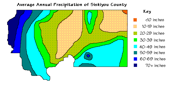
The western half of the county is mountainous so the incoming moisture from the Pacific Ocean is readily uplifted and precipitated out. The air descends after leaving the Klamath Ranges resulting in lower precipitation in the Shasta Valley. The air, still containing moisture, is again uplifted over the Cascade Range resulting in higher precipitation in a north-south band. There is a rain-shadow effect on the east side of the Cascades, resulting in low precipitation in northeasternmost Siskiyou County.
Mediterranean climates are largely influenced by the high pressure systems over the world's major ocean basins. During the summer the sun migrates poleward and the high pressure system follows. This results in the Hawaiian High being situated off the coast of California during the summer, preventing the extratropical cyclones from moving onshore during the summertime. Instead, the storms are forced northward, which is why Oregon and Washington receive more summertime rain than does California. During some years, the high pressure system is stronger or longer lasting than normal, resulting in lower-than-average precipitation. Droughts are potentially harmful to the economy and the natural environment so many Californians are interested in the weather. The goal of this study is to manipulate and examine satellite images to see if the drought's effect can be seen from space.
![]()
One drought-influenced scene and one non-drought scene was obtained by searching WebGlis for MultiSpectral Scanner (MSS) scenes acceptable to the parameters of the study. The ideal drought scene was to be from the end of the 1987-1992 drought period to show its full effects. Since post-drought scenes are not available through WebGlis, the ideal non-drought scene was to be from the period between 1983-1986 to lessen the influence of the earlier 1976-1977 drought. The two scenes were to be selected from the same season, preferably within a month of each other. The ideal scene will be taken in May or June, when vegetation is at its peak. These time constraints will be further constrained by the available data.
After searching WebGlis only two fully qualified images matched the criteria. Both scenes have low cloud cover (less than 10%), are Very Good in quality, and were taken during early June. The non-drought scene was taken on June 13, 1985 and the drought scene was taken on June 8, 1992 before that year's winter precipitation ended the drought.
The satellite scenes cover an area over 39,000 km2 (over 9,000,000 acres) in southern Oregon and northern California. An image file this large requires a lot of computer memory to manipulate and covers an area larger than the subject matter. Therefore, subscenes will be examined.
The procedures used to process the data are outlined in the previous section, Processing Multispectral Scanner Data with Idrisi.
To begin with, two subscenes were selected from each of the two satellite scenes using the WINDOW command. One subscene covers 1,368.8 km2 (3,382.4 acres) around Mount Shasta and includes Lake Shastina and Siskiyou Lake. The other subscene straddles the California - Oregon border and covers 8,961.9 km2 (22,145.6 acres) in the Klamath Basin. While this study's focus is on northern California, Upper Klamath Lake was included in one of the subscenes as it is a major part of the Klamath Basin system. These subscenes were selected as they had a relatively high percentage of water and varying vegetation.
After the subscenes were selected and created, each band was haze corrected and a 4/2 ratio made of each subscene. The 4/2 ratio was then made into a boolean image showing land and water and the area of each determined.
An NDVI ratio was made of each subscene for both years. The reason for this is to visually show vegetation vigor.
![]()
The Mount Shasta subscene contains 3,382.4 acres (1,368.8 km2). During 1985 water covered 9.0 % of this area while only 5.6 % was water in the 1992 drought year. The Klamath Basin subscene covered 22,145.6 acres (8,961.9 km2). In 1985 water covered 7.7 % of this area while in 1992 the figure was 4.7 %.
|
|
|
||
|
|
|
|
|
|
3,078.42 acres (1,245.77 km2) |
3,194.20 acres (1,292.63 km2) |
20,444.55 acres (8,273.49 km2) |
21,100.84 acres (8,539.08 km2) |
|
304.03 acres (123.03 km2) |
188.25 acres (76.18 km2) |
1,701.07 acres (688.39 km2) |
1,044.77 acres (422.80 km2) |
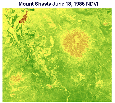
The Normalized Vegetation Indices can be viewed visually to get an overall impression of vegetation health and vigor. In the table below are NDVI satellite images of both subscenes for the 1985 non-drought year and the 1992 drought year. When viewing the larger images, pay special attention to Lake Shastina in the northwest corner of the Mount Shasta subscene. The single pivot-irrigation to the northeast of Lake Shastina in the 1985 scene was not irrigated at the time the 1992 scene was scanned. In the smaller Klamath Basin NDVI images you can see that the Tule Lake Sump has more water (brown) in the 1985 scene. Lower Klamath Lake and Miess Lake have enough water that they show up in the 1985 scene but not in the 1992 scene. Upper Klamath Lake in Oregon also has more water in the 1985 scene than in the 1992 scene.
|
|
|
||
|
June 13, 1985 |
June 8, 1992 |
June 13, 1985 |
June 8, 1992 |
 |
 |
 |
 |
![]()
Based on the visual NDVI images and the mathematically determined area of land and water using boolean images created from Band 4/2 ratio images, multispectral scanner data showed that the 1985 non-drought year was wetter than the 1992 climax of the 1987-1992 drought.
While water covers more area in the non-drought scene, as determined mathematically by the computer, it is not so apparent, based on the NDVI images, what the effects of the drought are on the natural vegetation.
This brief study was based on only two bands of multispectral data and yet we were able to see a great deal. If you browsed the first two sections of this web presentation you saw how many other things could be seen using only four bands of data scanned from space. The first multispectral scanners showed the world what we could see from space. Thematic Mapper (TM), a newer model scanner currently in operation, obtains seven bands of data. Imagine what we could see with seven bands! This year Landsat 7, with the new and improved Enhanced Thematic Mapper Plus, will be launched. With continued and improved coverage of the world, remote sensing is taking on an even greater importance in planning for the future. Learning to manipulate satellite data is personally rewarding and may lead to an interesting and enjoyable career.
![]()
I would like to thank the College of the Siskiyous for purchasing the two Landsat MultiSpectral Scanner scenes used in this study. Thanks also go to Emporia State University and Dr. James Aber for offering online courses and answering lots of questions.
![]()
Dale, John W., technical coordinator. Southern Cascades section in California Forest Health in 1994 and 1995. USDA Forest Service at http://r05s001.pswfs.gov/fpm/fh_94-95/m261d.htm
Eastman, J. Ronald. Idrisi for Windows User's Guide Version 2.0. Worcester, Massachusetts: Clark University, 1997.
Fay, James S. California Almanac, 7th edition. Santa Barbara, California: Pacific Data Resources, 1995.
Freeman, Linda. Climate of Siskiyou County in the Electronic Atlas of Siskiyou County at http://www.snowcrest.net/freemanl/atlas/climate.html
Greenpeace. "More Drought for California"" at http://www.greenpeace.org/~climate/database/records/zgpz0205.html
Los Angeles Times. "California Drought Proclaimed Over -- Finally" in The Tech. Friday, February 26, 1993. Volume 113, No. 9. at http://the-tech.mit.edu/V113/N9/briefs2.09w.html
USGS. WebGlis at http://edcwww.cr.usgs.gov/webglis/
![]()

This page prepared for Earth Science 775 Advanced
Image Processing
taught by James S. Aber at Emporia State
University
©1998 Linda Freeman