

Many of us have had the thrill of scanning one of our favorite photographs and seeing it displayed on a monitor! We place our carefully selected photograph face-down on the scanner, select the options we desire, and click the mouse. The scanner then makes several passes over the photograph, scanning the red, the green, and the blue (RGB). There are several varieties of scanners we can use to scan our photographs. In space there are different kinds of scanners which sense the Earth. I thought it would be wonderful to scan one of my favorite places on Earth, Mount Shasta, from Space. This section is a brief introduction to the Mount Shasta region using maps, photographs, digital elevation models, and satellite images.
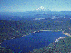
Let's begin our virtual tour of the Mount Shasta region by looking at a map showing the area covered in each satellite scene. Mount Shasta is the green, circular icon. The California - Oregon border is at 42 degrees North. Upper Klamath Lake is in the top central portion of the scene and the Klamath River flows diagonally across the scene to the southwest corner then on out to the Pacific Ocean. The Sacramento River has its origins on Mount Eddy then flows south to Shasta Lake before heading south through the Sacramento Valley.

The Pit River flows across the southeastern corner of the scene and into Shasta Lake. The Rogue River of Oregon flows across the northwestern portion of the scene. The horseshoe-shaped lake just outside the eastern boundary is Clear Lake in Modoc County. Most of Siskiyou County lies within the boundaries of this scene as well as parts of Shasta, Modoc, Trinity and Humboldt counties in California and Klamath, Jackson, and Josephine counties in Oregon. A closer view of the region showing the larger cities and roads is available by clicking on the above map.
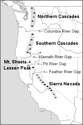
The Cascade Range stretches from Canada to northern California. In the United States the range is divided into different parts. The Northern Cascades of Washington are north of the Columbia River, which crosses the range creating a gap. The Southern Cascades of Oregon are between the Columbia River Gap and the Klamath River Gap. The California Cascades are set apart from the rest of the range by the Klamath River; the Pit River Gap then divides two of the most famous volcanoes in California, Mount Shasta and Lassen Peak. In addition to this four-part division of the Cascade Range, the range is also divided into the High Cascades, the generally higher, eastern portion of the range, and the older, more worn, Western Cascades.

Prior to zooming in on Mount Shasta, I'd like to give you a glimpse of some of the other Cascade volcanoes in the satellite scene. You will find that this region is quite volcanically diverse. Click on the volcano that you would like to learn more about.
 |
|
 |
|
 |
|
 |
|
 |
|
Just like city skylines become imprinted on those who live in sight of a large city, mountains have a tendency to become impressed in the minds of those who view the mountain day after day. You will find schoolchildren, from kindergarteners to high schoolers, drawing pictures of Mount Shasta during art class or in the margins of their notebooks. Since Mount Shasta can be seen from far distances, it has become a beacon to many people who live in northern California and southern Oregon.
Mount Shasta impresses visitors as much as it does residents. Clarence King, a geologist on the California State Geological Survey, said in 1870, "...the great point in the landscape is the cone of Shasta; its crest of solid white, its vast altitude, the pale-gray or rosy tints of its lavas, and the dark girdle of forest which swells up over cañon-carved foot-hills give it a grandeur equalled by hardly any American mountain." In 1873 Joaquin Miller wrote, "Lonely as God and white as a winter moon, Mount Shasta starts up sudden and solitary from the heart of the great black forests of Northern California." The naturalist John Muir stated, upon seeing Mount Shasta, "When I caught sight of it over the braided folds of the Sacramento Valley I was fifty miles away and afoot, alone and weary. Yet all my blood turned to wine, and I have not been weary since." C. Hart Merriam, who led the U.S. Biological Survey of Mount Shasta in 1898, called Mount Shasta "the pride of California." At the turn of the century, Theodore Roosevelt said, "I consider the evening twilight on Mount Shasta one of the grandest sights I have ever witnessed."

When heading north on Interstate 5 through the Upper Sacramento canyon (see painting Canyon View, circa 1880, by William Keith), one of the first views one has of Shasta is from the south with Castle Crags on the west and Mount Shasta straight ahead. It is a beautiful sight to behold and it thrills me every time I see it. The Crags are granitic spires and domes carved by glaciers. Even though the surrounding Trinity Mountains were also shaped by glaciers during the Quaternary, granite is more durable than the really old ultramafic rocks that were scraped to the North American continent as the heavy ocean floor subducted beneath the lighter continent.
 After leaving the canyon and entering the valley where Mount Shasta City
is located, the freeway veers to the left and skirts the west side of the mountain.
From Mount Shasta City, the mountain looms large and wide, and in the evening the
alpenglow turns the mountain into a wondrous site.
After leaving the canyon and entering the valley where Mount Shasta City
is located, the freeway veers to the left and skirts the west side of the mountain.
From Mount Shasta City, the mountain looms large and wide, and in the evening the
alpenglow turns the mountain into a wondrous site.
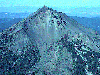
Between the towns of Weed and Mount Shasta City another Cascade volcano, Black Butte, points skyward on the east side of the freeway. It looks like a miniature of Mount Shasta, except that it is dark. Black Butte is a plug dome that formed about the same time as Shastina, the secondary peak on Mount Shasta.
We have our own special view of Mount Shasta from the town of Weed. Diller Canyon, a deep gash on the west side of Shastina, faces our town and provides us with a unique perspective.

If one was heading south on Interstate 5 they would see Mount Shasta as soon as they start to head down into Shasta Valley. From here, it looks like many other Cascade volcanoes, a rather steep cone rising over a thousand feet above the valley floor.

In the Shasta Valley are many hills that were formed from an ancient landslide off Mount Shasta. Heading south on Highway 97 affords another spectacular view of the mountain. There are still glaciers on Mount Shasta. On the northwest side glacial deposits occasionally flow across Highway 97.
Not many people see Mount Shasta from the east side, but to the people who live here, this is the mountain they know and love. Beautiful views are to be had when traveling east or west on Highway 89, especially since there are several deeply carved canyons on the southeast side of Mount Shasta.
Alt, David and Donald W. Hyndman. Northwest Exposures: A Geologic Story of the Northwest. Missoula, Montana: Mountain Press Publishing Company, 1995.
CASDE. VistaPro Files of Northern California at http://www-dial.jpl.nasa.gov/~steven/casde/vistapro/nocal_vp_a.html
Christiansen, Bob and Dan Miller. Air Photo of Black Butte from Faces of Mount Shasta Reveal Past Eruptions at http://volcanoes.usgs.gov/Hazards/Where/ShastaDanger/faces.html
College of the Siskiyous Library. The Mount Shasta Collection (pamphlet). Weed, California: College of the Siskiyous (date unknown).
DeLorme. Simply Streets USA (CD-ROM). Yarmouth, ME: DeLorme, 1997. http://www.delorme.com
English, Jane and Jenny Coyle. Mount Shasta... Where Heaven and Earth Meet. Mount Shasta, California: Earth Heart, 1996. See also http://www.eheart.com
Freeman, Linda. Mount Shasta: A Boreal Island in The Firecracker: The Newsletter of the Shasta Chapter, California Native Plant Society. Redding, California: Kinko's, March-April, 1998.
Freeman, Linda. A Virtual Tour of Lincoln Heights, California at http://www.snowcrest.net/geography/field/lincoln/
Hinckley, John. VistaPro 3.0 for Windows (CD-ROM). Virtual Reality Labs, Inc., 1993.
Miesse, William C. Mount Shasta: An Annotated Bibliography. Weed, California: College of the Siskiyous, 1993.
Miesse, William C. The Significance of Mount Shasta as a Visual Resource. Unpublished manuscript, 1989.
Miller, Joaquin. Life Amongst the Modocs: Unwritten History. San Jose, California: Urion Press, 1987 (Reprint of 1873).
Muir, John. Steep Trails. San Francisco, California: A Sierra Club Book, 1994.
USGS/Cascades Volcano Observatory. Medicine Lake Volcano, California - Lava Beds, California - Miscellaneous Images at http://vulcan.wr.usgs.gov/Volcanoes/MedicineLake/images.html
Walpole, Fred A. Yreka & Mt. Shasta, Siskiyou County, Cal., looking south east from American Memory Library of Congress Map Collections, 1639-1988 at http://memory.loc.gov/ammem/gmdhtml/gmdhome.html
World Data Center A for Glaciology. September 9, 1959 Aerial Photograph of Mount Shasta. University of Colorado, Boulder.
York, Kathy. Whaleback Mountain in Siskiyou County Landforms at http://cosweb.siskiyous.edu/class/geog1a/fall1996/whale.htm

This page prepared for Earth Science 775 Advanced
Image Processing
taught by James S. Aber at Emporia State
University
©1998 Linda Freeman