
Black Butte has gone through several name changes. John Muir called it the Black Butte and others named it Muir's Peak or Muir's Butte after him. It has been called Wintoon Butte and Little Butte. Because of its conical shape, it has also been called Sugarloaf and Cone Mountain. But if you were to see the "miniature" of Mount Shasta, you would see why "Black" has remained part of the toponym.
 Black
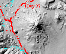
Butte is located at the base of Mount Shasta in northern California about
halfway between the towns of Weed and Mount Shasta City. Black Butte, a
6,325 foot plug dome, is located on the east side of the freeway opposite
the symbol "I-5" on the map to the right.
Black
Butte is located at the base of Mount Shasta in northern California about
halfway between the towns of Weed and Mount Shasta City. Black Butte, a
6,325 foot plug dome, is located on the east side of the freeway opposite
the symbol "I-5" on the map to the right.
Black Butte, made up of several dacite plug domes, formed at about the same time as Shastina around 9500 years ago. Plug domes are a special type of volcano with lava so thick and stiff it doesn't form a lava flow. Rather, the lava cools into angular blocks after it is slowly squeezed out of the vents. These rocks did not flow down the slope as lava, they rolled down the slope, after they cooled, forming the steep, rocky sides of Black Butte. Plug domes are relatively uncommon; the most famous example in the vicinity is Lassen Peak to the south.
 |
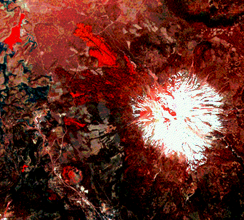
 This
composite image uses band 1/2 for the blue band, band 2 for the green band,
and band 3 for the red band. While both water and certain volcanic images
show up as red, the water tends to be smoother. Also, since maps can help
you decide if a red area is a lake or not, this image allows some volcanic
features to be readily observable. Click on this larger
view and you will see Black Butte, a dacite plug dome (also shown in
upper right corner), just to the east of I-5; the Lava Park flow on the
northwest side of Shasta (Lake Shastina is in the top left corner); and
other lava flows on Shasta's northwest flank. The dark gray patchy area
between Black Butte and Shasta is a deforested region. This
composite image uses band 1/2 for the blue band, band 2 for the green band,
and band 3 for the red band. While both water and certain volcanic images
show up as red, the water tends to be smoother. Also, since maps can help
you decide if a red area is a lake or not, this image allows some volcanic
features to be readily observable. Click on this larger
view and you will see Black Butte, a dacite plug dome (also shown in
upper right corner), just to the east of I-5; the Lava Park flow on the
northwest side of Shasta (Lake Shastina is in the top left corner); and
other lava flows on Shasta's northwest flank. The dark gray patchy area
between Black Butte and Shasta is a deforested region. |
 |
 This
image uses Bands 4, 3, and 1. Black Butte is the brownish, flower-shaped
feature in the top right quarter of the image to the east of I-5. Hammond's
Pond is in the northwest corner. If you click on the image to see the bigger
picture, try to find Diller Canyon on the west side of Shasta. It looks
like it's draining into Weed. The big image is so neat because the freeways,
railroads, dirt roads, rivers, and more are visible. Brown lines are roads.
The light blue areas are meadows, our lushest valley meadows. The meadows
that have more trees in them are the next-to-the-lightest blue, and the
light green. The tan areas are logged. The bright blue in the large image
is the fairly recent lava flow over on Highway 97 near Whitney Creek. This
image uses Bands 4, 3, and 1. Black Butte is the brownish, flower-shaped
feature in the top right quarter of the image to the east of I-5. Hammond's
Pond is in the northwest corner. If you click on the image to see the bigger
picture, try to find Diller Canyon on the west side of Shasta. It looks
like it's draining into Weed. The big image is so neat because the freeways,
railroads, dirt roads, rivers, and more are visible. Brown lines are roads.
The light blue areas are meadows, our lushest valley meadows. The meadows
that have more trees in them are the next-to-the-lightest blue, and the
light green. The tan areas are logged. The bright blue in the large image
is the fairly recent lava flow over on Highway 97 near Whitney Creek. |
![]() Back
to A Virtual Tour of Mount Shasta
Back
to A Virtual Tour of Mount Shasta
Freeman, Linda. Black Butte, California at http://www.snowcrest.net/geography/black/butte.htm
Harris, Stephen L. Fire Mountains of the West: The Cascade and Mono Lake Volcanoes. Missoula, Montana: Mountain Publishing Company, 1988.
Miesse, William C. Mount Shasta: An Annotated Bibliography. Weed, California: College of the Siskiyous, 1993.
Miller, C. Dan. Potential Hazards from Future Eruptions in the Vicinity of Mount Shasta Volcano, Northern California. Washington, D.C.: United States Government Printing Office, 1980.
Muir, John. Steep Trails. San Francisco, California: A Sierra Club Book, 1994.
United States Geologic Survey. DEM of Weed, California (east sheet) from 1:250,000-scale Digital Elevation Models for California at http://edcwww.cr.usgs.gov/glis/hyper/guide/1_dgr_demfig/states/CA.html
This page prepared for Earth Science 775 Advanced
Image Processing
taught by James S. Aber at Emporia State
University
©1998 Linda Freeman