
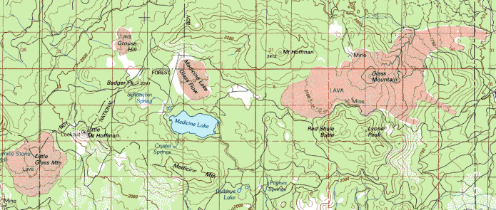
Topographic Map of Medicine Lake Highlands
The Modoc, Pit River, Shasta, and other local tribes have long utilized this region for salutary and spiritual reasons. Because of their cultural legacy and regard for the environment, they are generally opposed to a proposed geothermal plant being built in this sacred region. While it is not felt that the waters of Medicine Lake would be degraded, the power line may be built right between Medicine Lake and the Medicine Lake Lava Flow, which would certainly make this area less than pristine.
The Medicine Lake Highlands is an eastern extension of the Cascade Range. It's a real cool-looking region and I read, "This land of 'rocks that float and mountains of glass,' which was believed to resemble the moon, was selected for study by astronauts from the Manned Spacecraft Center in Houston, Texas during the summer of 1965 in preparation for the first manned moon landing." While this sounds rather like a legend, there is an unworldly feel to this place. Where else can one go iceskating during the summer in a land where mean maximum July temperatures are in the mid-80s?
Medicine Lake is sometimes called "The Crater Lake of California" as Medicine Lake is inside a large caldera 4 by 6 miles wide. Along the rim of the caldera are many vents including Mount Hoffman, Red Shale Butte, Medicine Mountain, Badger Peak, and Grouse Hill.
 Bands
4, 3, and 1 were used to create this interesting image to the right. Medicine
Lake is light blue. To the north is Medicine Lake Glass Flow. Glass Mountain
is a burnt orange color with a blue flow on the northeast being rhyolite-dacite
rather than obsidian. While this composite image distinguishes certain
features, it confuses irrigated fields, water, and recent basaltic flows,
which all show up as light blue.
Bands
4, 3, and 1 were used to create this interesting image to the right. Medicine
Lake is light blue. To the north is Medicine Lake Glass Flow. Glass Mountain
is a burnt orange color with a blue flow on the northeast being rhyolite-dacite
rather than obsidian. While this composite image distinguishes certain
features, it confuses irrigated fields, water, and recent basaltic flows,
which all show up as light blue.

In the satellite scene (Bands 1 haze corrected, 4/2, 3) to the left both water and recent lava flows show up as red. If you look at the large image, Lake Siskiyou is in the bottom left corner to the southwest of Mount Shasta and Medicine Lake is between the large, roundish lava flows in the northeastern part of the image. The blue mountains, about equidistant from Medicine Lake and in a line extending from Mount Shasta are obsidian; Little Glass Mountain to the west of Medicine Lake and Glass Mountain to the east. The reddish extension on the east side of Glass Mountain is the same feature you see in the Bands 4, 3, 1 image.
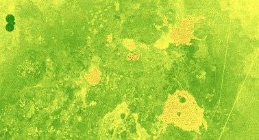 This
is a Normalized Difference Vegetation Index ratio. The real dark green
circles in the northwest corner are irrigated. The lighter, brownish-speckled,
amoeba-looking things are recent lava flows. The "islands" in
the Burnt Lava Flow Virgin Area to the southeast
of Medicine Lake (the lake has darker, speckled brown dots in it) are composed
of Sugar Pine, Ponderosa, Lodgepole Pine, and other vegetation atop craters
in three old cinder cones that were surrounding by newer aa (a real
rugged basaltic lava). The Burnt Lava Flow is believed to be one of the
youngest flows at 200 years old, give or take.
This
is a Normalized Difference Vegetation Index ratio. The real dark green
circles in the northwest corner are irrigated. The lighter, brownish-speckled,
amoeba-looking things are recent lava flows. The "islands" in
the Burnt Lava Flow Virgin Area to the southeast
of Medicine Lake (the lake has darker, speckled brown dots in it) are composed
of Sugar Pine, Ponderosa, Lodgepole Pine, and other vegetation atop craters
in three old cinder cones that were surrounding by newer aa (a real
rugged basaltic lava). The Burnt Lava Flow is believed to be one of the
youngest flows at 200 years old, give or take.
![]() Back
to A Virtual Tour of Mount Shasta
Back
to A Virtual Tour of Mount Shasta
Anderson, Charles A. Volcanoes of the Medicine Lake Highland California. Berkeley, California: University of California Press, 1941.
Doublehead Ranger District. Medicine Lake Highlands (pamphlet). Modoc National Forest, date unknown.
Elford, C. Robert. The Climate of Siskiyou County. Yreka, California: Farm Advisors Office of Siskiyou County, 1976.
Harris, Stephen L. Fire Mountains of the West: The Cascade and Mono Lake Volcanoes. Missoula, Montana: Mountain Publishing Company, 1988.
Maptech. TopoScout (CD) Version 2.01. Greenland, New Hampshire: Maptech, 1997.
McNutt, Steve. Medicine Lake Highland September 1988 Earthquake Swarm in California Geology, March 1989.
Miesse, William C. Mount Shasta: An Annotated Bibliography. Weed, California: College of the Siskiyous, 1993.
Sharp, Randall, et. al. Fourmile Hill Geothermal Development Project (Environmental Impact Statement and Report). State Clearinghouse #96062042, July 1997.
This page prepared for Earth Science 775 Advanced
Image Processing
taught by James S. Aber at Emporia State
University
©1998 Linda Freeman